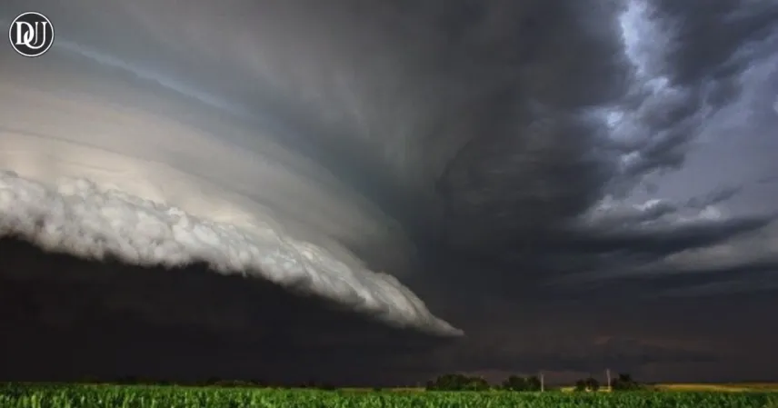
As weather systems intensify across the eastern United States, multiple regions are now facing a severe thunderstorm warning, prompting urgent alerts from meteorologists and emergency officials. Residents in the Washington, D.C. metro area and parts of the Southeast are advised to stay indoors and prepare for dangerous conditions that could affect both safety and daily activities.
DC Metro Braces for Heavy Storms
The National Weather Service has placed the entire DC metro area under a severe thunderstorm warning, with torrential rains, strong winds, and hail forecasted throughout the evening. Flash flood watches are also in effect, particularly for low-lying areas, where saturated grounds are expected to cause waterlogging and swift flooding.
Forecasters have indicated the risk of wind gusts up to 60 mph, capable of downing trees and power lines. The storm system moving into the capital has already caused power outages in surrounding counties and disrupted evening traffic. Commuters are advised to avoid driving unless absolutely necessary, especially in flood-prone zones.
Southeast Sees First Alert Weather Day
Meanwhile, in Tennessee and neighboring states, a First Alert Weather Day has been declared due to scattered severe thunderstorms moving in from the west. The storms are expected to reach peak intensity in the late afternoon and early evening hours. Local authorities have warned of potential hail and isolated tornadoes as the front moves eastward.
Emergency services are on high alert, especially in areas with recent heavy rainfall. Rivers and streams could breach their banks due to the additional downpour, compounding the risks.
Flood Watches and Thunderstorm Watches Continue
With a large portion of the Mid-Atlantic and Southeast under alert, the severe thunderstorm warning remains a significant concern. Flash flood watches remain active in several counties, and storm drains are struggling to cope with the fast-accumulating rainfall.
Authorities are encouraging residents to monitor local alerts, avoid water-covered roads, and stay indoors during lightning storms. In many communities, emergency shelters are being kept on standby in case evacuations become necessary.
What to Expect Overnight
The system is expected to gradually weaken after midnight, but some areas might still experience lingering thunder and moderate rain into the early morning hours. Cooler temperatures behind the front may bring temporary relief from the summer heat, but forecasters caution that another round of storms could follow later in the week.
Until then, the severe thunderstorm warning remains in place, and preparedness is key. Simple actions like securing outdoor furniture, charging devices, and checking flashlights can make a big difference during a weather emergency.
Stay Safe and Stay Informed
With so many variables in play, the severe thunderstorm warning issued today serves as a stark reminder of nature’s power. Whether in DC or the deeper South, residents should stay vigilant and prepared for sudden changes. As emergency teams remain on standby, public cooperation is essential in minimizing risks and damage.